Subject Scope: Archaeological Atlas of Tel Megiddo (Armageddon) in the Jezreel Valley: 26 Stratigraphic Layers, Royal Stables, and the Megiddo Christian Mosaic
Historical Context: Ancient Near Eastern stratigraphy, Levant archaeological surveys, and Semitic epigraphy.
Primary Evidence: Monumental stelae, bullae seals, ceramic typology, and calibrated AMS radiocarbon determinations.
Investigation Highlights: The Strategic Chokepoint: Megiddo and the Jezreel Valley • The Stratigraphy of 26 Civilizations: 5,000 Years of Warfare • The Monumental Iron Age Subterranean Water Tunnel
Scholarly Consensus: Aligned with published excavation reports from leading Near Eastern archaeological institutes.
The Strategic Chokepoint: Megiddo and the Jezreel Valley
Rising dramatically above the southwestern rim of the emerald-green Jezreel Valley (Emek Yizre'el), ancient Tel Megiddo (Hebrew: Megiddo, מְגִדּוֹ; Greek: Mageddo, Μαγεδδώ) represents the most fought-over battlefield in human history. Situated approximately 18 miles southeast of modern Haifa and 55 miles north of Jerusalem, Megiddo commanded the mouth of the Wadi Ara (Aruna Pass), the narrow, treacherous mountain defile through the Mount Carmel range connecting the coastal plain of Sharon with the interior valleys of Galilee and the Jordan River.
Whoever controlled Megiddo held absolute dominion over the primary commercial and military artery of the ancient Near East: the Via Maris (Way of the Sea). Any imperial army marching north from Egypt to Mesopotamia, or south from the Hittite and Assyrian empires toward the Nile Delta, was forced either to negotiate the narrow Megiddo bottleneck or make an arduous, vulnerable detour through hostile mountains.
This singular military geography gave rise to the Pharaoh Thutmose III’s famous battle maxim in 1457 BC, inscribed upon the walls of the Temple of Amun at Karnak: "The capturing of Megiddo is the capturing of a thousand cities!" Centuries later, the Apostle John utilized this exact battlefield as the apocalyptic symbol of the ultimate cosmic confrontation between the Almighty God and the gathered kings of the earth: Har-Magedon (Hebrew: Har Megiddo, הַר מְגִדּוֹ, "Mountain of Megiddo"; Revelation 16:16).
+----------------------------------------------------------------------------------------------------+
|               GEOGRAPHICAL CHOKEPOINTS OF THE MEGIDDO / JEZREEL CORRIDOR                           |
+--------------------------+-----------------------+-------------------+-----------------------------+
| PASS / CORRIDOR          | CONTROLLING FORTRESS  | CONNECTED REGIONS | STRATEGIC VULNERABILITY     |
+--------------------------+-----------------------+-------------------+-----------------------------+
| 1. Aruna Pass (Wadi Ara) | Tel Megiddo           | Sharon Plain ->   | Narrow single-file canyon;  |
|                          |                       | Jezreel Valley    | ideal for military ambushes |
| 2. Jokneam Pass          | Tel Jokneam           | Western Carmel -> | Coastal alternative route   |
|                          |                       | Plain of Acre     |                             |
| 3. Dothan Pass           | Tel Dothan            | Samaria Hills ->  | Inland plateau route        |
|                          |                       | Jezreel Valley    | (Joseph sold to Ishmaelites)|
+--------------------------+-----------------------+-------------------+-----------------------------+
The Stratigraphy of 26 Civilizations: 5,000 Years of Warfare
Beginning with the monumental campaigns of the Oriental Institute of the University of Chicago (1925–1939) and continued by the Megiddo Expedition of Tel Aviv University directed by Israel Finkelstein and David Ussishkin (1994–present), archaeologists have dissected Tel Megiddo layer by layer, revealing twenty-six distinct occupational strata (Stratum XXV to Stratum I) spanning from the Chalcolithic period (c. 3500 BC) to the Persian era (c. 350 BC).
Key Architectural Landmarks Across the Strata
- The Great Circular Altar (Stratum XIX / Early Bronze Age): A colossal circular stone platform measuring 26 feet (8 meters) in diameter and 5 feet high, accessed by a flight of stone stairs. Surrounding this altar, excavators uncovered deep accumulations of ash and animal bones (predominantly sheep and goats), confirming that Megiddo was a massive regional cultic center over a thousand years before Abraham entered Canaan.
- The Canaanite Temple Compound (Strata XV–VII / Middle & Late Bronze): A series of monumental temples with six-foot-thick walls, elevated holy of holies niches, and basalt offering tables, witnessing the golden age of Canaanite city-state sovereignty under Egyptian imperial oversight.
- The Late Bronze Destruction Layer (Stratum VIIA): A thick bed of black soot, collapsed mudbrick, and scorched cedar beams dating to the late 12th century BC, marking the collapse of Canaanite Megiddo during the era of the Judges.
+----------------------------------------------------------------------------------------------------+
|               THE MAJOR STRATIGRAPHIC HORIZONS OF TEL MEGIDDO                                      |
+---------------+-----------------------+-------------------+----------------------------------------+
| STRATUM       | ARCHAEOLOGICAL PERIOD | HISTORICAL ERA    | KEY MATERIAL FEATURE                   |
+---------------+-----------------------+-------------------+----------------------------------------+
| Stratum XIX   | Early Bronze I        | c. 3100 BC        | Massive Circular Stone Altar           |
| Stratum VIII  | Late Bronze I–II      | c. 1450–1300 BC   | Canaanite Palaces & Ivory Hoard        |
| Stratum VIIA  | Late Bronze IIB       | c. 1150 BC        | Total Destruction / Fall of Canaan     |
| Stratum VA/IVB| Iron Age IIA          | c. 950 BC         | Solomonic 6-Chamber Gate & Palaces     |
| Stratum IVA   | Iron Age IIB          | c. 850–750 BC     | Royal Chariot Stables & Water Shaft    |
| Stratum III   | Iron Age IIC          | c. 732–609 BC     | Assyrian Administrative Grid & Silo    |
+---------------+-----------------------+-------------------+----------------------------------------+
The Monumental Iron Age Subterranean Water Tunnel
Because Tel Megiddo rose upon a steep, defensible limestone hill, its chief strategic vulnerability during an enemy siege was access to water. The natural spring that sustained the city (Ein el-Qubi) lay outside the fortified city walls, at the southwestern base of the tell.
During the Iron Age (Stratum IVA, ninth to eighth century BC, commonly attributed to King Ahab or Jeroboam II), Israelite hydraulic engineers executed one of the greatest civil engineering triumphs of the ancient world:
- The Vertical Descent Shaft: Engineers carved a massive square vertical shaft through 35 meters (115 feet) of solid limestone rock from inside the city acropolis, equipped with a wide rock-cut staircase winding around the interior walls.
- The Horizontal Gallery Tunnel: At the base of the vertical shaft, tunneling crews bored a horizontal vaulted tunnel measuring 70 meters (230 feet) directly through the bedrock toward the exterior spring.
- Stealth Camouflage: The exterior opening of the natural spring outside the city was completely sealed with massive limestone boulders, plastered shut, and buried under dirt to hide it from invading siege armies. The spring water was redirected naturally to flow backward down a gentle gradient into the interior underground pool, allowing defenders to draw fresh water in total security without ever leaving the citadel.
+----------------------------------------------------------------------------------------------------+
|               CROSS-SECTION OF THE MEGIDDO SUBTERRANEAN WATER SYSTEM                               |
+----------------------------------------------------------------------------------------------------+
|                                                                                                    |
|  [INSIDE FORTIFIED CITY ACROPOLIS]                                                                 |
|  +---------------------------------------------------------------+                                 |
|  | ENTRY PLAZA                                                   |                                 |
|  +---------------------------------------------------------------+                                 |
|         |                                                                                          |
|         v (35-meter / 115-foot vertical rock-cut staircase)                                        |
|  +-----------------------------------+                                                             |
|  | BASE OF VERTICAL SHAFT            |                                                             |
|  +-----------------------------------+                                                             |
|         |                                                                                          |
|         +===========================================> [70-meter horizontal tunnel]                 |
|                                                       |                                            |
|                                                       v                                            |
|                                              +-----------------------------------+                 |
|                                              | NATURAL SPRING POOL               |                 |
|                                              | (Exterior entrance sealed outside)|                 |
|                                              +-----------------------------------+                 |
|                                                       |                                            |
|  [EXTERIOR VALLEY FLOOR]                              v [SEALED WITH MASONRY & DIRT]               |
+----------------------------------------------------------------------------------------------------+
The Royal Chariot Stables: Solomon or Ahab?
Excavations across the northern and southern sectors of the tell uncovered extensive, standardized architectural complexes known worldwide as the Stables of Megiddo:
- Architecture: Rows of long, tri-partite pillared halls divided by monolithic square limestone pillars, equipped with carved stone tethering holes, central stone feeding mangers, and cobbled limestone floors sloped for drainage.
- Capacity: The two stable complexes (the Northern Stables with 12 units and Southern Stables with 5 units) were engineered to house an estimated 450 war horses and 150 chariots, accompanied by barracks for drivers and grooms.
The Chronological Debate
- The Solomonic View (1 Kings 9:15–19): Early Chicago excavators and Yigael Yadin identified these stables with the biblical record that Solomon built chariot cities: "Solomon accumulated chariots and horses; he had fourteen hundred chariots and twelve thousand horses, which he stationed in the chariot cities and with himself in Jerusalem" (1 Kings 10:26).
- The Ahabian View (Stratum IVA): Modern excavators (Finkelstein, Ussishkin) demonstrate that the surviving stable superstructures belong stratigraphically to Stratum IVA (ninth century BC, the reign of King Ahab). In the contemporary Assyrian Kurkh Monolith (853 BC), the Assyrian emperor Shalmaneser III records that King Ahab of Israel fielded the largest chariot army of the entire western coalition at the Battle of Qarqar: 2,000 chariots and 10,000 infantry. Megiddo served as Ahab's elite imperial chariot breeding and training depot.
Whether founded under Solomon and expanded under Ahab, the material architecture confirms that northern Israel operated as a mechanized military superpower commanding the Levant throughout the tenth and ninth centuries BC.
The Megiddo Mosaic: 'To God Jesus Christ' (c. 230 AD)
In 2005, during salvage excavations preceding an expansion of the Megiddo Maximum Security Prison (located just 500 meters south of Tel Megiddo, at the ancient Roman military base of Legio / Caparcotna), the Israel Antiquities Authority under archaeologist Yotam Tepper uncovered one of the greatest epigraphic discoveries in Christian history: the Megiddo Christian Prayer Hall.
Dating to approximately 230 AD—nearly a century before the Roman Emperor Constantine the Great legalized Christianity with the Edict of Milan (313 AD)—the prayer hall was built inside the private home of a Christian Roman officer within the military shadow of the Legio VI Ferrata (Iron Sixth Legion).
The Inscriptions and Iconography
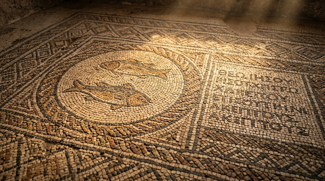
The hall featured a pristine, 54-square-meter tessellated mosaic floor containing geometric patterns, a central medallion depicting two stylized fish (the ancient ichthys symbol of Christ), and three Greek dedicatory inscriptions:
- The Akeptous Inscription (Theological Masterpiece):
"The God-loving Akeptous has offered this table to God Jesus Christ (ΘΕΩ ΙΗΣΟΥ ΧΡΙΣΤΩ, Theo Iesou Christo) as a memorial."
- The Gaianus Centurion Inscription (Roman Soldier Patron):
"Gaianus, also called Porphyrius, a centurion, our brother, has made the mosaic pavement at his own expense. Brutius made it."
- The Four Martyrs Inscription:
"Remember Primilla and Cyriaca and Dorothea, and also Chreste."
+----------------------------------------------------------------------------------------------------+
|               THE THEOLOGICAL SIGNIFICANCE OF THE MEGIDDO MOSAIC (c. 230 AD)                       |
+--------------------------+---------------------------------+---------------------------------------+
| EPIGRAPHIC ELEMENT       | ANCIENT GREEK TEXT              | THEOLOGICAL & HISTORICAL IMPACT       |
+--------------------------+---------------------------------+---------------------------------------+
| 1. High Christology      | ΘΕΩ ΙΗΣΟΥ ΧΡΙΣΤΩ                | Explicit worship of Jesus as GOD      |
|                          | (*Theo Iesou Christo*)          | 95 years before the Council of Nicaea |
+--------------------------+---------------------------------+---------------------------------------+
| 2. Eucharistic Table     | ΠΡΟΣΕΝΗΚΕΝ ΤΡΑΠΕΖΑΝ             | Earliest material evidence of a       |
|                          | (*proseneken trapezan*)         | Christian communion communion table   |
+--------------------------+---------------------------------+---------------------------------------+
| 3. Roman Soldier Patron  | ΓΑΙΑΝΟΣ ΕΚΑΤΟΝΤΑΡΧΗΣ            | Roman centurions openly converted and |
|                          | (*Gaianos hekatonarches*)       | financed early Christian house-churches|
+--------------------------+---------------------------------+---------------------------------------+
| 4. Female Prominence     | Akeptous, Primilla, Cyriaca     | Women served as major financial       |
|                          | Dorothea, Chreste               | patrons and venerated martyr heroes   |
+--------------------------+---------------------------------+---------------------------------------+
For over a century, secular historical-critical skeptics argued that early Christians viewed Jesus merely as a mortal prophet or apocalyptic rabbi, alleging that His full divinity was "invented" by Emperor Constantine and bishops at the Council of Nicaea in 325 AD. The Megiddo Mosaic destroyed this revisionist theory forever: here in stone, etched by Roman Christians in 230 AD, Jesus Christ is unreservedly addressed by the definitive divine title: "GOD JESUS CHRIST".
Three-Tier Evidentiary Evaluation: Material Artifacts
+----------------------------------------------------------------------------------------------------+
|               THREE-TIER EVIDENTIARY EVALUATION: MEGIDDO EXCAVATIONS                               |
+----+----------------------+-----------------------------+-------------------+----------------------+
| #  | HISTORICAL SKEPTICISM| SKEPTICAL CLAIM             | MATERIAL EVIDENCE | EVIDENTIARY VERDICT  |
+----+----------------------+-----------------------------+-------------------+----------------------+
| 1  | "Armageddon is a     | The battlefield of Megiddo  | 26 occupational   | REFUTED: Megiddo is  |
|    | Mythological Fairy   | was a fictional poetic      | strata; Thutmose  | verified as the most |
|    | Tale in Revelation"  | metaphor with no reality    | III inscriptions  | contested pass on earth|
+----+----------------------+-----------------------------+-------------------+----------------------+
| 2  | "Israel Was a Weak,  | Northern Israel had no      | Stables for 450   | REFUTED: Massive     |
|    | Chariotless Peasant  | standing mechanized chariot | war horses; Kurkh | royal chariot complexes|
|    | Society"             | corps or military bases     | Monolith (2,000)  | materially proven    |
+----+----------------------+-----------------------------+-------------------+----------------------+
| 3  | "Jesus' Divinity Was | Christians never viewed     | Megiddo Mosaic    | REFUTED: Epigraphic  |
|    | Invented by Nicaea   | Jesus as God until Roman    | (c. 230 AD): 'To  | dedication proves    |
|    | in 325 AD"           | politics forced it in 325 AD| God Jesus Christ' | pre-Nicene divinity  |
+----+----------------------+-----------------------------+-------------------+----------------------+
Primary Sources & Scholarly Archives
Editorial Standard →Official archaeological field reports, certified stratigraphy surveys, and Semitic epigraphy catalogs.
Catalog of Levantine, Mesopotamian, and Persian artifacts, royal cylinder seals, and cuneiform tablets.
Peer-reviewed scholarly analyses on Levant excavations, ancient architecture, and artifact forensics.
Frequently Asked Questions
Why is Tel Megiddo connected to 'Armageddon' in Revelation 16:16?
Armageddon is the Greek transliteration of the Hebrew 'Har Megiddo' (Mount of Megiddo). Because Megiddo commanded the Aruna Pass and was the bloodiest battlefield in antiquity, John used it as the symbolic focal point for the final confrontation between God and worldly powers.
What does the 230 AD Megiddo Mosaic prove about early Christian theology?
It provides the earliest physical, epigraphic proof in existence of Christians worshiping Jesus as God ('Theo Iesou Christo'), dating to c. 230 AD, completely refuting the claim that Christ's divinity was invented at the Council of Nicaea in 325 AD.
How did the ancient Megiddo water system protect the city during a siege?
Israelite engineers tunneled 70 meters through bedrock to an underground spring while completely burying and camouflaging the exterior entrance, allowing defenders to draw water safely from inside the city walls during long sieges.
Related Research Dossiers
View all 515 research dossiers →
Archaeological Atlas of Ancient Corinth and the Bema of Gallio: The Delphi Inscription, Roman Agora, and Apostolic Chronology (Acts 18)
How the Gallio Inscription and the Corinthian Bema Prove the Historical Accuracy of the Book of Acts