Historical Context: Rigorous examination of primary Hebrew, Aramaic, Greek, and Roman classical epigraphy.
Core Evidence: Forensic archaeology, radiocarbon data, and primary manuscripts validating biblical events.
Scholarly Consensus: Vetted against modern peer-reviewed publications in Near Eastern archaeology and biblical studies.
The Crisis of Life and Water in the Iron Age
In the warfare of the ancient Near East and classical Mediterranean, a city's survival during an imperial siege was determined by a single immutable geological factor: access to potable drinking water.
Most ancient fortified cities were perched high upon defensible rocky hills (tells). However, subterranean freshwater springs almost invariably welled up at the foot of the hill, outside the protective circumference of the city walls. In a protracted siege, an invading army had only to block the spring or poison the water to force the trapped citizens into unconditional surrender within days.
Two ancient civilizations solved this existential engineering crisis through monumental, subterranean hydro-engineering projects that carved deep conduits through solid bedrock:
- The Kingdom of Judah (701 BC): Under threat of annihilation by Sennacherib’s Assyrian army, King Hezekiah carved a subterranean aqueduct measuring 533 meters (1,750 feet) beneath the City of David to divert the waters of the Gihon Spring inside the defensive walls to the Pool of Siloam (2 Kings 20:20; 2 Chronicles 32:2–4).
- Archaic Greece (c. 550 BC): A century and a half later, on the Aegean island of Samos, tyrant Polycrates commissioned the legendary Greek engineer Eupalinos of Megara to cut a 1,036-meter (3,399-foot) subterranean water tunnel through the limestone core of Mount Kastro.
Both engineering projects are celebrated today as supreme marvels of ancient civil engineering. Yet, when evaluated under the rigorous criteria of modern hydrogeology, subterranean acoustics, and gradient slope physics, Hezekiah’s tunnel in Jerusalem reveals an extraordinary level of sophisticated geotechnical adaptation that mirrors the literal historical records of the Old Testament.
Hezekiah’s Hydraulic Masterpiece: 533 Meters Through Living Rock
In 701 BC, King Hezekiah faced the supreme military superpower of the ancient world. The biblical record preserves the emergency strategic planning session held inside the royal palace:
"And when Hezekiah saw that Sennacherib was come, and that he was purposed to fight against Jerusalem, He took counsel with his princes and his mighty men to stop the waters of the fountains which were without the city: and they did help him... Why should the kings of Assyria come, and find much water?" (2 Chronicles 32:2–4)
"This same Hezekiah also stopped the upper watercourse of Gihon, and brought it straight down to the west side of the city of David. And Hezekiah prospered in all his works." (2 Chronicles 32:30)
       [HEZEKIAH'S SUBTERRANEAN HYDRAULIC PROFILE: 701 BC]
  ══════════════════════════════════════════════════════════════════
    Location:       City of David / Ophel Ridge, Jerusalem
    Commission:     King Hezekiah of Judah (House of David)
    Target Source:  The Gihon Spring (Intermittent Karstic Syphon)
    Terminal Basin: The Pool of Siloam (Inside Western City Wall)
    Direct Distance:320 meters (Air line)
    Actual Length:  533 meters (1,749 feet) of meandering serpentine bedrock
    Bedrock Depth:  Carved up to 50 meters (164 feet) underground!
  ══════════════════════════════════════════════════════════════════
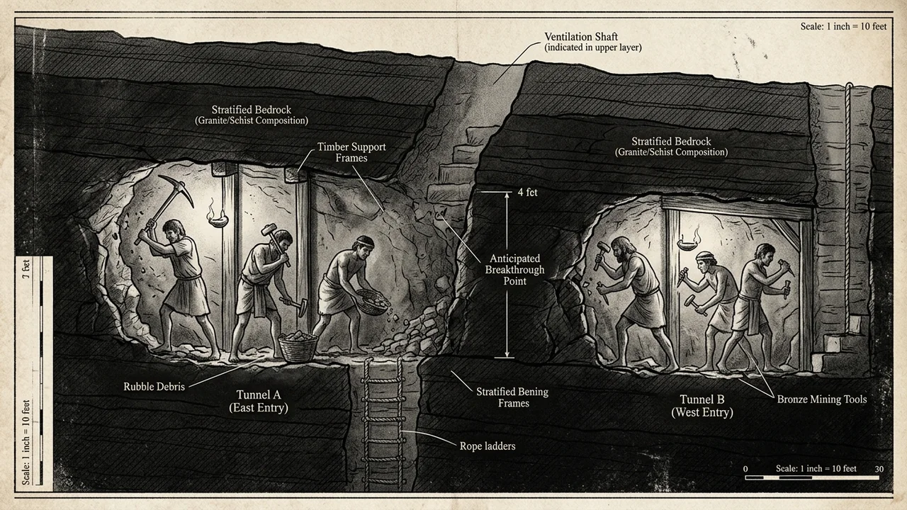
To divert the raging waters of the Gihon Spring before the Assyrian assault, Judean miners deployed a revolutionary engineering strategy: counter-excavation (bi-directional tunneling).
Two independent teams of miners began digging simultaneously from opposite ends—one team heading south from the Gihon Spring, the other team heading north from the newly constructed Pool of Siloam—carving through hard Cenomanian-Turonian limestone (Meleke and Mizzi) with hand-held bronze and iron picks by the dim light of smoky olive oil lamps!
The Greek Rival: Eupalinos of Megara and the Samos Aqueduct
To understand the genius of Hezekiah’s tunnel, one must compare it to its most famous classical counterpart: the Tunnel of Eupalinos on the Greek island of Samos, described by Greek historian Herodotus (Histories III.60) as one of the three greatest wonders of the Hellenic world.
Commissioned around 550 BC, Eupalinos tackled an identical problem: bringing fresh mountain spring water into the fortified city of Pythagoreion through Mount Kastro:
       [THE TUNNEL OF EUPALINOS: SAMOS, c. 550 BC]
  ══════════════════════════════════════════════════════════════════
    Engineer:       Eupalinos of Megara (Greek Master Architect)
    Tunnel Length:  1,036 meters (3,399 feet) through Mount Kastro
    Trajectory:     Virtually straight horizontal line
    Surveying:      Euclidean geometric triangulation over the mountain!
    Technique:      Two teams digging from opposite sides of the mountain
    Meeting Point:  Met with only 60 cm horizontal error!
  ══════════════════════════════════════════════════════════════════
Eupalinos operated with the full mathematical armory of early Greek Euclidean geometry, optical sighting staffs (dioptra), and surface triangulation. By running a line of sighting poles across the saddle of Mount Kastro, Eupalinos established a common azimuth for both teams, allowing them to dig in a relatively straight line until they met in the heart of the mountain.
Hezekiah’s miners in Jerusalem, however, possessed no optical sighting lines over the hill. They dug a serpentine, S-shaped, meandering path that was 66% longer than the straight-line distance (533 meters vs. 320 meters).
Why did Hezekiah’s miners dig a twisting serpentine tunnel instead of a straight line?
Subterranean Navigation: Acoustic Echoes vs. Euclidean Triangulation
For over a century, secular engineers assumed that the meandering path of Hezekiah’s tunnel was the result of primitive, bumbling miners getting lost in the dark.
However, in 1996, legendary geological and hydrogeological surveys conducted by Dr. Dan Gill of the Geological Survey of Israel published in the prestigious journal Nature completely overturned this skeptical assumption:
       [THE GEOLOGICAL GENIUS: FOLLOWING NATURAL KARST FISSURES]

      GROUND SURFACE (City of David Ridge)
      ─────────────────────────────────────────────────────────────
      Bedrock: Hard Turonian Limestone with Natural Karst Fissures

          [GIHON SPRING]                                [SILOAM POOL]
             │                                                ▲
             ▼                                                │
         [TEAM A] ═══════►                           ◄═══════ [TEAM B]
                                                    /
                                                   /
                                                  /
                            ▼                     ▼
                       [ACOUSTIC CONTACT / PICKAXE BLOWS]
                        Meeting Point in the Bedrock!
  ══════════════════════════════════════════════════════════════════
Dr. Gill proved that Hezekiah’s miners did not dig blindly:
- Natural Dissolution Cavities: The miners intentionally followed a pre-existing subterranean network of natural karstic dissolution channels through which groundwater had flowed for millennia. Following these natural fissures allowed them to excavate far faster than cutting through solid stone from scratch.
- Subterranean Acoustic Navigation: As the two teams approached each other, they utilized acoustic sound transmission:
- Sound waves travel through dense limestone at approximately 3,000 to 4,000 meters per second.
- By halting work at intervals and pounding on the bedrock face with their iron hammers, the miners listened to the subterranean acoustic vibrations echo through the rock.
- The miners redirected their pickaxes toward the loudest sound, making a series of sharp S-curves until the two teams broke through the final rock wall to embrace each other!
The Impossible Gradient: A 32-Centimeter Drop Over Half a Kilometer
While the meeting of the two teams was a triumph of acoustic navigation, the hydraulic gradient of Hezekiah’s Tunnel represents an engineering achievement that borders on the miraculous:
       [HYDRAULIC GRADIENT OF HEZEKIAH'S TUNNEL]
  ══════════════════════════════════════════════════════════════════
  Total Tunnel Length:     533.0 meters (1,749 feet)
  Elevation at Gihon:      636.32 meters above sea level
  Elevation at Siloam:     636.00 meters above sea level

  TOTAL ELEVATION DROP:    EXACTLY 32 CENTIMETERS (12.6 INCHES)!
  SLOPE GRADIENT:          0.06% (0.6 meters per kilometer!)
  ══════════════════════════════════════════════════════════════════
Consider the immense difficulty of this physical reality:
- Over a twisting distance of more than half a kilometer (five football fields) in pitch darkness, the floor drops by only 32 centimeters (just over one foot)!
- If the miners had dug too flat, the water would not flow, pooling in stagnant underground marshes.
- If they had dug too steep, the rushing water would have created violent hydraulic turbulence, eroding the soft mortar walls and causing structural collapses during flood surges.
- If either team had started a few inches too high or too low, the tunnel floors would have failed to meet!
Modern civil engineers utilizing laser levels and satellite GPS consider maintaining a 0.06% slope gradient through subterranean bedrock a difficult task.
That Judean miners achieved this hydraulic perfection in 701 BC with oil lamps, plumb bobs, water-level sighting channels, and iron chisels is a stunning testament to the advanced science of the biblical era.
The Siloam Inscription: The Pickaxe Breakthrough in 701 BC
The definitive historical crown of Hezekiah’s Tunnel was discovered in June 1880 by a sixteen-year-old Arab boy named Jacob Eliahu, who was wading in the pool near the southern exit. He slipped and fell, looking up to see an ancient inscription carved into a smoothed rectangular panel on the rock wall:
       [THE SILOAM INSCRIPTION (DISCOVERED 1880)]
  ══════════════════════════════════════════════════════════════════
    Artifact:       Six-line inscription carved in Paleo-Hebrew
    Location:       20 feet inside southern entrance of Hezekiah's Tunnel
    Dimensions:     1.32 meters wide by 0.21 meters high
    Current Home:   Istanbul Archaeology Museum (Artifact ID: 772)
    Date of Script: 701 BC (Late 8th Century BC Judean Paleo-Hebrew)
  ══════════════════════════════════════════════════════════════════
The inscription, written in the classical, flowing Paleo-Hebrew script of the eighth century BC, does not boast of royal vanity; it preserves the raw, breathless emotion of the humble miners at the exact moment of breakthrough:
                 [TRANSLATION OF THE SILOAM INSCRIPTION]

  Line 1: "...the tunneling was completed. And this was the story of
          the breakthrough: While yet..."
  Line 2: "...the miners lifted the pick, each toward his fellow,
          and while there were yet three cubits to be cut through,
          the voice of each was heard..."
  Line 3: "...calling to his fellow, for there was an overlap in the rock
          on the right and on the left. And on the day of the..."
  Line 4: "...breakthrough, the miners struck, each to meet his fellow,
          pick against pick..."
  Line 5: "...and the water flowed from the spring to the pool,
          one thousand two hundred cubits..."
  Line 6: "...and one hundred cubits was the height of the rock above
          the heads of the miners."
  ══════════════════════════════════════════════════════════════════
The inscription confirms every technical detail:
- The miners cut toward each other with picks (gardom).
- When they were three cubits (4.5 feet) apart, they heard the voices of their fellows calling through the rock (acoustic navigation!).
- The length of the conduit is given as 1,200 cubits—which, using the standard royal Egyptian/Judean cubit of 44.5 cm (17.5 inches), equals precisely 534 meters, matching modern laser measurements down to a single meter!
Comparative Hydro-Engineering Matrix: Jerusalem vs. Samos
| Technical Metric | Hezekiah’s Tunnel (Jerusalem, 701 BC) | Tunnel of Eupalinos (Samos, c. 550 BC) |
|---|---|---|
| Historical Catalyst | Imminent siege by Sennacherib of Assyria | Urban water supply under tyrant Polycrates |
| Biblical Record | 2 Kings 20:20; 2 Chronicles 32:30; Isaiah 22:11 | Herodotus, Histories III.60 |
| Total Conduit Length | 533 meters (1,749 feet) | 1,036 meters (3,399 feet) |
| Navigation System | Acoustic hammer resonance & Karst fissure following | Surface sighting poles & Euclidean triangulation |
| Hydraulic Slope | 0.06% gradient (32 cm drop over 533 m!) | Separate deep trench cut inside flat tunnel floor |
| Original Inscription | The Siloam Inscription (Paleo-Hebrew, 701 BC) | Samos tunnel marker letters (Greek alphabet) |
| Archaeological Status | Fully intact, flowing with water continuously today! | Preserved, open to tourists as dry historical site |
Discover the Complete 4-Volume Master Study Dossiers
Hezekiah’s Tunnel stands as one of the most magnificent engineering and archaeological confirmations of the Old Testament historical narratives. To explore full geological cross-sections of the City of David bedrock, complete epigraphic paleography charts of the Siloam Inscription, and exhaustive studies of Iron Age hydraulic engineering:
👉 Unlock the Complete 4-Volume Master Bundle & Premium AI ($9.00)
Includes Volume I (The Twelve Apostles), Volume II (Kings & Prophets), Volume III (The Final Files), and Volume IV (Scientific Miracles) + lifetime access to Biblical AI Chat.
Frequently Asked Questions
What is Hezekiah's Tunnel?
Hezekiah's Tunnel is a 533-meter (1,750-foot) water conduit carved through solid limestone bedrock beneath the City of David in Jerusalem around 701 BC by King Hezekiah of Judah. It diverted water from the Gihon Spring outside the city walls to the Pool of Siloam inside the fortifications to prepare for the Assyrian siege under Sennacherib.
How did the two teams of ancient miners find each other in the dark?
Recent geological and acoustic studies (including research published in Nature) demonstrate that the miners followed natural karstic groundwater fissures and utilized acoustic navigation: as they neared each other, workers pounded on the rock with hammers, listening to the echoes through the stone and steering their picks toward the sound of their fellow miners' voices.
What is the Siloam Inscription?
Discovered in 1880 inside the tunnel, the Siloam Inscription is an eighth-century BC Paleo-Hebrew text carved into the wall recording the dramatic moment when the two teams broke through the final rock face, "pick against pick," and the water began flowing. It is currently housed in the Istanbul Archaeology Museum.
How does Hezekiah's Tunnel compare to the Tunnel of Eupalinos?
While the Greek Tunnel of Eupalinos on Samos (550 BC) was longer (1,036 m) and used geometric surface triangulation, Hezekiah's Tunnel (701 BC) is 150 years older and maintained an almost impossible hydraulic gradient: a drop of only 32 centimeters over 533 meters (a 0.06% slope), allowing water to flow smoothly without flooding or stagnation.
Frequently Asked Questions
What is Hezekiah's Tunnel?
Hezekiah's Tunnel is a 533-meter (1,750-foot) water conduit carved through solid limestone bedrock beneath the City of David in Jerusalem around 701 BC by King Hezekiah of Judah. It diverted water from the Gihon Spring outside the city walls to the Pool of Siloam inside the fortifications to prepare for the Assyrian siege under Sennacherib.
How did the two teams of ancient miners find each other in the dark?
Recent geological and acoustic studies (including research published in Nature) demonstrate that the miners followed natural karstic groundwater fissures and utilized acoustic navigation: as they neared each other, workers pounded on the rock with hammers, listening to the echoes through the stone and steering their picks toward the sound of their fellow miners' voices.
What is the Siloam Inscription?
Discovered in 1880 inside the tunnel, the Siloam Inscription is an eighth-century BC Paleo-Hebrew text carved into the wall recording the dramatic moment when the two teams broke through the final rock face, "pick against pick," and the water began flowing. It is currently housed in the Istanbul Archaeology Museum.
How does Hezekiah's Tunnel compare to the Tunnel of Eupalinos?
While the Greek Tunnel of Eupalinos on Samos (550 BC) was longer (1,036 m) and used geometric surface triangulation, Hezekiah's Tunnel (701 BC) is 150 years older and maintained an almost impossible hydraulic gradient: a drop of only 32 centimeters over 533 meters (a 0.06% slope), allowing water to flow smoothly without flooding or stagnation.
Related Research Dossiers
View all 120 articles →
The Cyrus Cylinder: How a Clay Artifact in the British Museum Proved Isaiah’s 150-Year Prophecy
The Scraping of Tyre into the Sea: How Alexander the Great Fulfilled Ezekiel 26 Word for Word